
Update: SAWS will consider this as a ‘likely’ or ‘probable’ tornado observation
Based on the preliminary evidence SAWS DRR will consider this a 'likely' or 'probable' tornado observation.

The SA Weather Services cannot verify that the wind storm that hit the area this afternoon was a tornado.
ALSO READ:
A video of a tornado-like funnel circulated on social media and widespread damage was reported to homes in Madadeni’s section 7.
Kevin Rae, the SAW’s chief forecaster, said based on the preliminary evidence, ‘SAWS DRR will consider this a ‘likely’ or ‘probable’ tornado observation, pending additional supporting data or information, such as damage caused (if any), damage path, and width of damage.’
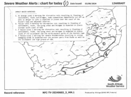
He said SAWS currently had a Yellow Level 2 warning (i.e., a high chance of minor impacts) in place for Monday, June 3, for severe thunderstorms resulting in strong damaging winds, valid for the eastern parts of Free State as well as the escarpment and high ground of KZN province.
Rae continued to state that with the evidence currently available, it was not possible to speculate as to how ‘dangerous’ or ‘strong’ the tornado was.
“Even the weakest EF0 and EF1 tornadoes are associated with strong damaging winds, have the capacity to cause damage, and should be considered ‘dangerous’.”
‘Skinny’ vortex tubes, according to him, are no reliable indication of the weakness or strength of a tornado.
However, he said conversely, wide or fat tornado vortex tubes are often (but not always) indicative of strong or violent tornadoes.
“At this current time (16:00 on Monday, June 3), SAWS is not aware of any damage reports and/or injuries to people in association with this particular event. If the event occurred over an open, unpopulated area, it is quite possible that no damage occurred,” he said.
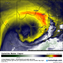
With reference to the attached satellite images, valid for 13:15 local time (11:15 UTC) today, June 3, 2024, he said one can clearly identify a line of thunderstorm squall-line development, oriented along a north/south axis, passing through the Newcastle/Utrecht KZN area.
He warned that an upper air cut-off low pressure system is currently positioned over South Africa, associated with strong wind shear, driving the development of cold-season (winter) storms, which may become severe in some cases.
“The reported date, time, and location of the photo or video correlated well with the position of the squall line over N. KZN at 13:15 local time. Further thunderstorms are expected over KZN this evening, and the possibility of further severe storms (possibly associated with weak tornadoes) cannot be ruled out,” Rae concluded.
See images below:
The news provided to you in this link has been investigated and compiled by the editorial staff of the Newcastle Advertiser, a sold newspaper distributed in the Newcastle area. Please follow us on Youtube and feel free to like, comment, and subscribe. For more local news, visit our webpage, follow us on Facebook and Twitter, and request an add on our WhatsApp (082 874 5550).


