Watch: Free State woman’s stop to take pics ends in tornado capture
A viral tornado video captured on farmland outside Heilbron has sparked questions about SA weather patterns – and we have answers.
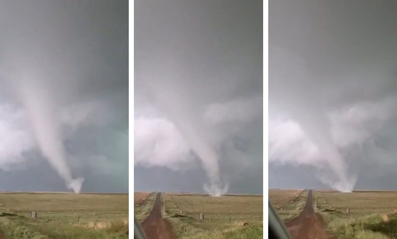
“I was on my way home from town and stopped to take pictures of the storm clouds when the tornado started forming. It was an amazing but also frightening experience.”
With these words, Tanya van Rooyen describes the moment she captured a video that has gone viral on social media. She recorded the footage at around 15:00, about 15km outside Heilbron in the Free State, on the Vegkop road.
She told Caxton Network News that it all happened in an instant. “The storm approached very fast and was accompanied by strong winds and heavy lightning. Moments after this video, heavy rain started to pour down.”
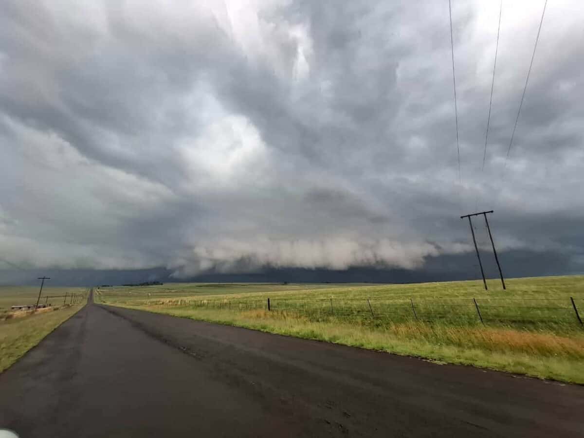
South African Weather Service (SAWS) meteorologist Lehlohonolo Thobela confirmed that thunderstorms in the area became more fierce in the afternoon. He added that a severe thunderstorm warning had been issued. According to Thobela, gusts in the region, combined with wind shear, convergence and sufficient moisture, led to the formation of convective clouds, which later developed into a supercell. “The conditions were favourable for a tornado to form.”
He said no further impacts had been reported, and it appears the tornado occurred over an open field, causing little or no damage.
“Based on these findings, SAWS has classified the event as an EF0 tornado – the weakest category on the Enhanced Fujita Scale, with estimated wind speeds of 105–137km/h.”
These tornadoes typically result in minor damage, such as broken branches, shallow-rooted trees being pushed over and light damage to roofs. “While EF0 tornadoes are relatively weak, they remain dangerous weather phenomena, and the public is urged to always exercise caution during severe thunderstorms,” he added.
Tornadoes in South Africa
Yesterday’s tornado follows a tornado in Harrismith, also in the Free State, on November 6. This triggered the question of whether the province is tornado-prone. Thobela said that research has shown typical conditions conducive to tornadic and severe-convective activity – namely, moist, converging air, low-level shear and unstable environments colliding with cooler triggers – are frequently found in parts of South Africa. He notes that historical and contemporary analyses show that many of South Africa’s tornadoes, and even a kind of ‘tornado belt’, occur in the Highveld regions and eastern provinces, including Gauteng, the Free State, Mpumalanga and KZN.
He added that historical event analyses also note a seasonal peak for tornadoes in the midsummer months (November–March), as investigated by the Water Research Commission in previous years. “Importantly, tornadoes are not limited strictly to the core summer; there are documented events in spring (September–October) and late summer.”
He said this supports the sense that warm moisture environments with triggers from cool environments are critical indicators of tornadoes occurring during this time of the year.
Supercell tornadoes
Thobela mentioned that research on a notable tornadic supercell on December 11, 2017, (in the highveld) found that conditions were driven by strong low-level moisture and significant boundary-layer vertical wind shear, exactly the ingredients observed in this case.
He said a relevant recent study (Liesker, Dyson & Becker) found that these supercells are most common in October to November, which is early in the convective season (spring to early summer). “Their preferred tracks average lifetime is about an hour and 12 minutes, with a horizontal speed of 41km/h and travelling about 49km, generally moving from the southwest, shifting more southerly as the season progresses.”
There also seems to be some influence of topography, especially in eastern Mpumalanga and highveld regions, on where supercells form. “This is consistent with the idea that the interaction of terrain, moisture and shear helps define preferred corridors for severe cell development, which could explain spatial clustering of the severe thunderstorm reports.”
Watch the video:
Van Rooyen explained to Parys Gazette that she could see a few corrugated iron sheets being picked up and blown around by the tornado.
“It was the first time we’ve experienced anything like this here,” she told the newspaper.
An enquiry was sent to the Free State Department of Co-operative Governance and Traditional Affairs and Human Settlements to find out if any damage was reported in the area. It was still being verified at the time of publishing.
Not uncommon in South Africa
Whenever a tornado hits South Africa, social media fills with ‘what is happening to the weather?’ posts. But according to SAWS, tornadoes are not new here.
We’re simply seeing more of them because smartphones and social media now capture what once went undocumented.
SAWS says tornadoes can occur anywhere thunderstorms form, with most historically reported in Gauteng, the Free State, KZN (between Pietermaritzburg and Ladysmith) and the northern former Transkei, often in mountainous areas. Around 65% are weak (F0–F1) and over 90% fall below F3 strength, although South Africa has seen stronger events such as the 1998 Harrismith (F2) and 1999 Mount Ayliff (F4) tornadoes.
SAWS adds that even internationally, tornado prediction remains limited – radar can typically give only about 20 minutes’ warning.
Tornadoes may be uncommon, but they are a long-standing part of South Africa’s weather, not a new phenomenon.
Breaking news at your fingertips… Follow Caxton Network News on Facebook and join our WhatsApp channel.
Nuus wat saakmaak. Volg Caxton Netwerk-nuus op Facebook en sluit aan by ons WhatsApp-kanaal.
Read original story on www.citizen.co.za